Monday, January 9, 2012
Creating a new permanent route
View Talmage to SF 200k in a larger map
I work in Talmage, just outside of Ukiah in Mendocino County, about 2-3 days a week. I have ridden up there on many occasions--at least once a year on the Buddhist Bicycle Pilgrimage, and on a couple of occasions by myself. I thought why not create a RUSA permanent so that when I ride it I can get RUSA credit for it--perhaps even getting a R12 by riding the route at least once a month. I have also ridden up from the Bay Area on different routes, so I was playing around with the map for a while. This route is perhaps the shortest way to do it and still fit it into a 200k. Currently as it stands from Talmage Store to Mason and Helleck in the Marina in San Francisco it's 125 miles, pretty close to 200km. The next step is to find suitable controls along the route. I will probably ride the route myself to tweak it.
Tuesday, January 3, 2012
Santa Cruz 3-Day Trip by Bikes: Part 4--Bike Review
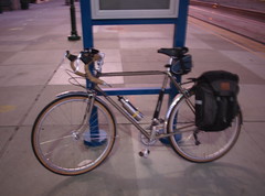
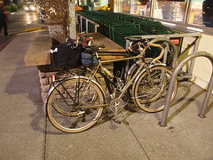
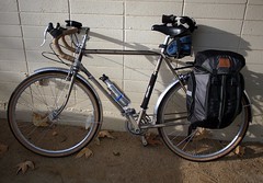
 M and I took very different bikes to carry our medium load (15-25 lbs) to and from Santa Cruz this time. My Kogswell P/R and M's Trek 720 do share some similarities. Both use standard-sized tubings that make for more flexible ride, and both were running 650b wheels (though the 720 is a conversion). The P/R was designed to carry the main load in the front, and I achieve this using the combination of Roseland Porteur Rack and Ruth Works Porteur Bag. The porteur bag is pretty big (16x12x12 cubic inches ~ 38 liters), and on this occasion I put these things in it:
- a touring map
- change of clothes, which included a pair of underwear, a north face long-sleeve base-layer top, a short-sleeved Novara wool jersey, and a gap wool sweater (and M's fleece jacket)
- U-lock with cables,
- 7 rolls of brown rice and tofu sushi,
- a bag of chocolate-almond-cashew trail mix,
- several energy bars
- a meal worth of soba noodles and a small jar home-made spicy sesame sauce.
- a New York Review for reading,
- a triangle to be visible,
- a travel coffee mug,
- necessity: wallet, cellphone, ipod touch, and charger for the iPod
- tools, spare tube (which became handy as I got a flat on the way back 1 mile away from the train station), and a frame pump
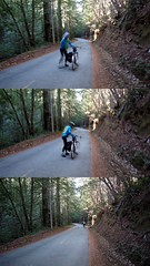
 This didn't fill the bag up (in comparison, a pair of bike packer panniers from Ortlieb carries 50 liters of stuff). I tried to arrange the stuff so that the weight is even across the platform of the rack. The handling feels heavy, but not in a way where I felt the bike was squirrely. As I rode, the bike with the load felt steady, and follows a straight line easily. When I climbed off the saddle, I need to pay attention not to sway the pressure of my body from side-to-side too much, as this is the time I felt the weight of the front load on my hands and arms. Descending with load is stable and predictable. In short, the low-trail design did what it supposed to do with 20-25 lbs of load up front. On high-torque climbing, I did feel the frame flex a little more, but not to an extend where I felt like I was bending the frame more than propelling it forward.
 Monday, January 2, 2012
Santa Cruz 3-day Trip by Bikes: Part 3--Eureka Canyon Road
 We woke up around 8AM in the morning in Santa Cruz after riding here from San Jose and spending a great day watching the ocean and chilling. Today we are riding back to San Jose, but not the way we came. Soquel-San Jose Road can be an exhilarating descent, but riding up on it may not be as fun. Today our plan was to ride west first through towns of Capitola, Aptos, and Corralitos, then up Eureka Canyon Road to the ridge and continue on Highland Way back to rejoin Summit Road. This will add about 17 miles to our trip and make it a 52-mile ride. With our haul, this is not easy, but the gradient on all the climbs today should be pretty gentle.
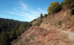
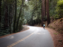
 Eureka Canyon Road is a winding, shaded, fairly well-paved and mostly narrow road. At times there is only one lane. The grade is very gentle. We were able to chat almost all the way up and I was riding mostly on my big chain ring. The road is lined with different kinds of beautiful tall trees and we were constantly greeted by birds and squirrels. For most of the time our view didn't go much beyond the canyon and the creek running beside the road. As we climbed higher views of the canyon below and the surrounding hills emerged. Toward the top near the junction with Highland Way the pavement is not as good (but still very good) and the road is more exposed. On this cold but clear day, sun was a much welcomed sight to warm us up a bit.
 We got to Highland and rode on the ridge for a good half a dozen miles. There was no significant climbs, but some gentle rollers. The road has a mixture of forest and wide vista of the canyons, mountains, and even a glimpse of the ocean below. Highland eventually turned into Summit Road. After taking a break at the Highland Market, we got to Old Santa Cruz Hwy and began the descent down to San Jose. The trip downhill is pretty fast, and we rode fast on back on the Los Gatos Creek Trail. About a mile away from the train station I hit a tack on the pavement and had to fix the flat. Good thing it was so close to the destination so i didn't have to ride with low pressure for long. We were both very tired from the trip and napped on the Amtrak ride home. It was a fun Christmas trip!
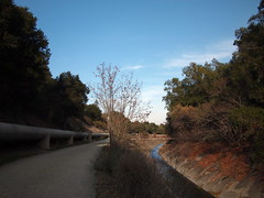
Here again, is the slideshow for the whole trip:
Santa Cruz 2-day Trip by bikes: Part 2
 On Box-in day, we woke up in the Opal Cliff neighborhood of Santa Cruz, after riding here from San Jose yesterday. Our hosts have already left. We slept in a little later than we would usually. What do we do for breakfast? M tossed around the idea of going downtown to eat at Saturn Cafe, a vegetarian diner. I searched around for a vegetarian restaurant closer-by that also serves breakfast, and came across Dharmas Restaurant. It was approximately a mile from where we stayed. Most of the shops were closed for the day still. It was foggy and chilly, but not too frigid.
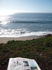 Dharmas is a trippy place (read about its history and tussle with McD's here), with paintings of different religious figures and a 80's type of decor. It's not a purely vegan restaurant, but most of the items can be requested to be made vegan. I ordered a vegan breakfast burrito, which has country-style potatoes, curry-stir-fried tofu, guacamole, salsa, and refried beans. M. ordered a pesto scrambled Tofu. Both dishes were exceptional, and the portion was good for hungry cyclists.
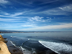
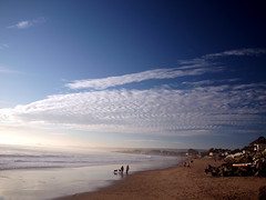
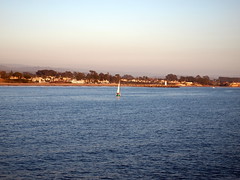 After breakfast we grabbed some reading and walked out to look for a nice spot on the beach. We walked east on Cliff Drive first all the way to the top of a small hill. From there we could see the Capitola Wharf. But there was no where to really sit. We walked westward toward the city and found a bench on a bluff at the end of a street not too far from where we stayed. M. took a short nap while I read some and watched the ocean for most. Occasionally she would open her eyes and one of those times she spotted some dolphins playing in the water not too far from shore. Below us on the beach lots of folks were out on this beautiful day, running, walking, playing with their dogs. By mid-afternoon we felt thoroughly chilled and soft. M said, "let's go see the sea lions".
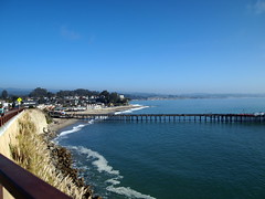
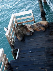 In February we walked on the wharf and chanced upon a pack of sea lions lying on a deck. We grabbed out bikes and rode along the water toward the Boardwalk in Santa Cruz. It was near sunset now and the view of the water was stunning. We made it to the wharf with plenty of sun light still, but not as many sea lions were on the deck. The ambiance near the wharf is wonderful and the sunset is gorgeous again (the sunset on Christmas Day was superb!).
Hard to believe that it's dinner time again, and since we had such a good breakfast we decided to go back to Dharmas again. This time we got the main meal as well as a vegan chocolate cake. We excused the indulgence by telling ourselves that we would be going on a 52-mile ride back to San Jose tomorrow hauling our stuff with us.
It was only 9PM when we got back and soon we felt asleep. It was a good day. (Below is the slideshow for all three days; part 3 of 3 will be the next post)
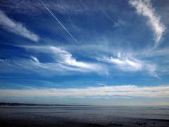
Santa Cruz 3-day trip by Bike: Part 1--Quiet Christmas Day to Santa Cruz
(Here is the set of pictures on flickr for the whole trip. But I will break the write-up into parts)
We stayed around for the holiday season, and looked for a short trip locally where we can ride our bikes and relax some. Originally we were planning on going to Mendocino, but the threat of rain (which didn't materialize) and the lack of affordable accommodation steered us to look for an alternative location. In February we took the train and rode to Santa Cruz for an overnight trip, and had lots of fun. So we decided to see if we can stay do it again. In February, we rode to Santa Cruz from the San Jose Amtrak station, hung out, and then took the HWY 17 Express Bus back to San Jose. This time, we planned on riding over and back (on a different way) to San Jose.
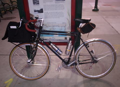
Christmas morning was very cold. According to the weather report when we left our house at approximately 6:30AM it was 30 degrees F. I took my Kogswell and pack all my stuff and some of M's stuff in the Ruth Works porteur bag that I got from Ely several months ago. The 15x12x12" bag can fit a lot of stuff, and on this occasion it contained my change of clothing, 8 seaweed rolls (made with brown rice, braised tofu, carrot and mushroom), a meal worth of soba noodles and a canister of home-made spicy sesame sauce, some energy bars, my camera, cellphone, iPod Touch, and wallet, a touring map, lock (both U and cable), and warm clothes (a wool sweater for me and a fleece for M). M is using her Trek 720 (650b conversion) for touring purpose for the first time. She carried a Sakaroo (made by Arkel) pannier with her change of clothing, a pair of street shoes (since she was wearing SPD shoes on this occasion), locks, a book, and our toiletry. Between the two of us we also carried 3 bottles of water in 3 Klean Kanteen bottles.
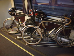
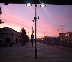
 The Amtrak train came online at 7:12AM, and we were fortunate to get floor racks for bikes. It was very quiet, as most people were probably still sleeping, and probably already at their destination for the holidays. San Jose was a little warmer, but the street was just as quiet. We rolled quickly through the first handful of miles until we got on to the Los Gatos Creek Trail, which is nearly 10 miles long and would take us to Lexington Reservoir. In February, even though we were riding at around the same time of the day, but tons of people were already out. This morning we hardly saw anyone besides flocks of ducks and geese. We traded pulls and move swiftly on this extremely pleasant trail. Both of us were wearing heart-rate monitors as we are training for some big rides this year and want to begin to build some base. We were doing 16-18 MPH and the heart rate stayed pretty low.
 The later stretches of the trail has hard-packed dirt as the surface, followed by a very short stretch of uphill and flat gravel roads. The last stretch is a path along the wall of the dam going up to the reservoir. We took off some layers as some climbing miles awaited. To get to Old Santa Cruz Highway, which is the road that will take us a long way toward Santa Cruz, we rode on a dirt path right next to the automobile-only Highway 17. The half a mile or so of dirt path, after a dry stretch in the weather was no trouble for our 650b tires. M commented on how she felt more assured riding her 650b'ed Trek 720 than she did in February when she was riding her 700c Trek 620.
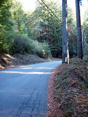
 Old Santa Cruz Highway is a shaded, well-paved and winding road that has a gentle upward gradient from north to south. It was beautiful in the morning, and we saw one other cyclist on the road, and maybe a handful of cars. Sun is more prominent now, but under the tall trees we didn't feel any heat. We remarked how it must be nice to ride through this stretch in the summer. Another gem around this area is Ogallala Warpath Road, which is a smaller side road that runs parallel to Old Santa Cruz Highway for a short while. The road is even quieter, and takes us through a dreamy neighborhood among tall trees and lined with pine needles. After exiting the Warpath, we climbed a little further until we reached Summit Road.
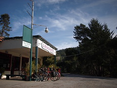
 Now we are on the ridge. We went southeast for a mile or so, heading toward Soquel-San Jose Road, which is what eventually would take us into Santa Cruz. However, we took Morrell Cutoff Road a mile or 2 prior to the intersection with Soquel-San Jose. Morrell Cutoff is a wooded back road with less than perfect pavement and some winding descents. On this trip it fits the motif perfectly. We saw lots of birds and people's backyards. Soon we came upon Soquel-San Jose. The road is a long and gentle descent down to the town of Soquel. We stopped at the Casalegno's Store as we did in February. We didn't expect it to be open, but we knew the store has benches outside for us to take a break and eat some food.

 It wasn't long after we began to roll again we entered the town of Soquel. It was noon at this point, and though more folks were out by now, it was still relatively quiet. We looked for the place we are staying for two nights--a room in a house I found on airbnb.com--and we were glad to find that the house was a block from the beach. Since it wasn't check-in time yet. We found a shady spot and watched the surfers tackled the waves for a while. It was gorgeous. After getting into our room and cleaned up a bit, we took a long walk along the water and stayed until past sunset. Given that it's Christmas night and most places were probably closed. We cooked the soba noodles we brought and made sesame noodles. It was a good day of riding and relaxing on the beach.
We stayed around for the holiday season, and looked for a short trip locally where we can ride our bikes and relax some. Originally we were planning on going to Mendocino, but the threat of rain (which didn't materialize) and the lack of affordable accommodation steered us to look for an alternative location. In February we took the train and rode to Santa Cruz for an overnight trip, and had lots of fun. So we decided to see if we can stay do it again. In February, we rode to Santa Cruz from the San Jose Amtrak station, hung out, and then took the HWY 17 Express Bus back to San Jose. This time, we planned on riding over and back (on a different way) to San Jose.
Christmas morning was very cold. According to the weather report when we left our house at approximately 6:30AM it was 30 degrees F. I took my Kogswell and pack all my stuff and some of M's stuff in the Ruth Works porteur bag that I got from Ely several months ago. The 15x12x12" bag can fit a lot of stuff, and on this occasion it contained my change of clothing, 8 seaweed rolls (made with brown rice, braised tofu, carrot and mushroom), a meal worth of soba noodles and a canister of home-made spicy sesame sauce, some energy bars, my camera, cellphone, iPod Touch, and wallet, a touring map, lock (both U and cable), and warm clothes (a wool sweater for me and a fleece for M). M is using her Trek 720 (650b conversion) for touring purpose for the first time. She carried a Sakaroo (made by Arkel) pannier with her change of clothing, a pair of street shoes (since she was wearing SPD shoes on this occasion), locks, a book, and our toiletry. Between the two of us we also carried 3 bottles of water in 3 Klean Kanteen bottles.
The Amtrak train came online at 7:12AM, and we were fortunate to get floor racks for bikes. It was very quiet, as most people were probably still sleeping, and probably already at their destination for the holidays. San Jose was a little warmer, but the street was just as quiet. We rolled quickly through the first handful of miles until we got on to the Los Gatos Creek Trail, which is nearly 10 miles long and would take us to Lexington Reservoir. In February, even though we were riding at around the same time of the day, but tons of people were already out. This morning we hardly saw anyone besides flocks of ducks and geese. We traded pulls and move swiftly on this extremely pleasant trail. Both of us were wearing heart-rate monitors as we are training for some big rides this year and want to begin to build some base. We were doing 16-18 MPH and the heart rate stayed pretty low.The later stretches of the trail has hard-packed dirt as the surface, followed by a very short stretch of uphill and flat gravel roads. The last stretch is a path along the wall of the dam going up to the reservoir. We took off some layers as some climbing miles awaited. To get to Old Santa Cruz Highway, which is the road that will take us a long way toward Santa Cruz, we rode on a dirt path right next to the automobile-only Highway 17. The half a mile or so of dirt path, after a dry stretch in the weather was no trouble for our 650b tires. M commented on how she felt more assured riding her 650b'ed Trek 720 than she did in February when she was riding her 700c Trek 620.Old Santa Cruz Highway is a shaded, well-paved and winding road that has a gentle upward gradient from north to south. It was beautiful in the morning, and we saw one other cyclist on the road, and maybe a handful of cars. Sun is more prominent now, but under the tall trees we didn't feel any heat. We remarked how it must be nice to ride through this stretch in the summer. Another gem around this area is Ogallala Warpath Road, which is a smaller side road that runs parallel to Old Santa Cruz Highway for a short while. The road is even quieter, and takes us through a dreamy neighborhood among tall trees and lined with pine needles. After exiting the Warpath, we climbed a little further until we reached Summit Road.
Now we are on the ridge. We went southeast for a mile or so, heading toward Soquel-San Jose Road, which is what eventually would take us into Santa Cruz. However, we took Morrell Cutoff Road a mile or 2 prior to the intersection with Soquel-San Jose. Morrell Cutoff is a wooded back road with less than perfect pavement and some winding descents. On this trip it fits the motif perfectly. We saw lots of birds and people's backyards. Soon we came upon Soquel-San Jose. The road is a long and gentle descent down to the town of Soquel. We stopped at the Casalegno's Store as we did in February. We didn't expect it to be open, but we knew the store has benches outside for us to take a break and eat some food.It wasn't long after we began to roll again we entered the town of Soquel. It was noon at this point, and though more folks were out by now, it was still relatively quiet. We looked for the place we are staying for two nights--a room in a house I found on airbnb.com--and we were glad to find that the house was a block from the beach. Since it wasn't check-in time yet. We found a shady spot and watched the surfers tackled the waves for a while. It was gorgeous. After getting into our room and cleaned up a bit, we took a long walk along the water and stayed until past sunset. Given that it's Christmas night and most places were probably closed. We cooked the soba noodles we brought and made sesame noodles. It was a good day of riding and relaxing on the beach.
Subscribe to:
Comments (Atom)